This post was originally published on March 24 as part of a post about the SDF attack on the Tabqa dam.
Geo-locating photographs shared on Twitter
We’d like to thank @CivilWaralSham for help in finding the location of these images.
Several images of SDF fighters on the dam were shared on social media on March 24. We can’t be sure when they were taken but the accounts posting them said they were taken on that date.
قوات سوريا الديمقراطية على سد الطبقة pic.twitter.com/RFUg4uORsH
— Jamal Bali (@JamalBali1) March 24, 2017
Image of SDF controlled area of Tabqa dam. ISIS putting up resistance in the remaining parts. #Raqqa pic.twitter.com/7Gx9UorVo7
— Afarin Mamosta (@AfarinMamosta) March 24, 2017
wêneyên destpêkê yên Bendava #Feratê ..#Xezeba_firatê
الصور الاولى لسد #الفرات او سد الطبقة#غضب_الفرات pic.twitter.com/gtxyplBVCL— Hoşeng Hesen (@HosengHesen) March 24, 2017
The location
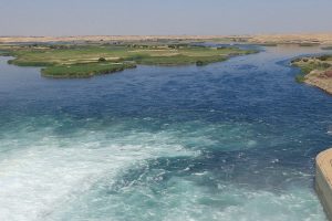
The Tabqa Dam is a large structure in northern Syria, about 40km (25 miles) from Raqqa city. The dam is 60m (200 ft) high and 4.5km (2.8 miles) long, and is the largest dam in Syria.

We believe the images shared are of the North Channel Inlet, known as the Al-Rey inlet, which channels water from the reservoir to the north. The SDF has controlled territory to the north of the dam for weeks.

Several structures around the inlet match structures seen in the images shared on Twitter.

The large steel structure – highlighted in orange – is seen in three of the pictures shared by three different Twitter users.
The security box –highlighted in green – is in the centre of the road to the right of the steel structure. It is visible in more recent satellite imagery that we can’t publish due to copyright. The road in the background of this image curves to the right, consistent with the road on the north side of the inlet.
The small building – highlighted in pink – is closer to the water’s edge. It’s visible in two photographs.
The other smaller structures near it – highlighted in yellow – appear in two photographs. These are also visible in more recent satellite imagery. They appear to have steel loops on top. These could have been used to move them into position by crane.
Several of the same structures – the large steel structure, the security box and the two small buildings by the water’s edge – can bee seen in a YPG Press Office video published on YouTube on March 23:

Conclusion
The images shared on Twitter were taken at the North Channel Inlet. There is no imagery we’ve seen that confirms the SDF have moved further south than this point.
Geo-locating SDF video
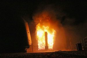
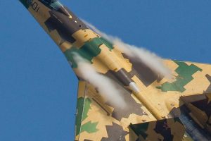
The SDF Press Office published a video on YouTube on March 24 showing a helicopter firing guns, a fighter talking to camera and a cloud of smoke in the distance.
We geo-located this video to the Jaabar Arch, approximately 2.7km (1.7 miles) north-northeast of the North Channel Inlet of the Tabqa Dam.
Screenshots from the video
We think the helicopter is likely to be a US-made Apache AH-64 attack helicopter, although the image is too indistinct to be sure. Alternatively, it could be a US-made UH-60 Blackhawk utility helicopter.
Geo-locating the video

The Jaabar Arch is a clearly identifiable structure, highlighted in red in the above image.
The wall in the other image – highlighted in orange – is apparent later in the video.
In the image of the smoke cloud, there is a line of pylons visible in the distance to the right of the person with binoculars. This power line is marked below.

The smoke cloud could be in the Suwaydīyah Dam Hamlets area, to the north of the river, or further south. Range is extremely difficult to estimate, but the angle is correct.
Conclusion
The SDF video was shot at the Jaabar Arch, near the Tabqa Dam.